
Technology
MCR-Master
Brings chassis and collaborative robot management, vision calibration, maps, stations, navigation and data monitoring together for commissioning and operation on one platform.
Talk to an expertRobot status
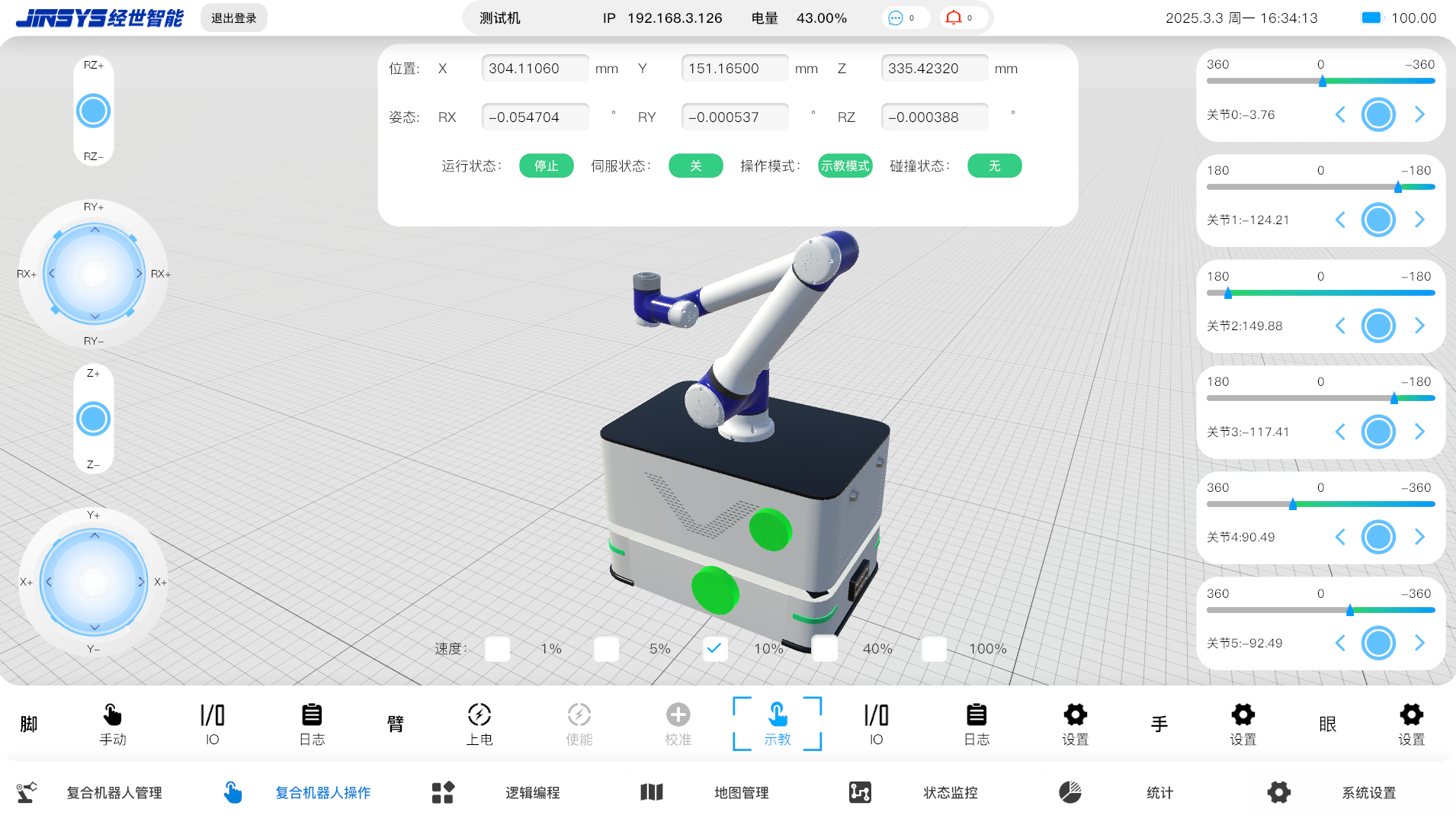
- Test robot
- Battery: 43.00%
- Stopped
- Servo off
- Teach mode
- No collision
Cartesian position
- X: 304.11060 mm
- Y: 151.16500 mm
- Z: 335.42320 mm
- RX: −0.054704°
- RY: −0.000537°
- RZ: −0.000388°
Joint teaching
- Joint 0: −3.76°
- Joint 1: −124.21°
- Joint 2: 149.88°
- Joint 3: −117.41°
- Joint 4: 90.49°
- Joint 5: −92.49°
Unified controls
- Base: manual, I/O, logs
- Arm: power, enable, calibrate, teach, I/O, logs, settings
- Gripper and vision settings
- Speed: 1% / 5% / 10% / 40% / 100%
MCR-Master Mobile Manipulator Operating System
MCR-Master is a mobile robot operating platform developed by JINSYS that integrates chassis and collaborative robot management, vision calibration, maps, stations, navigation and data monitoring. It is easy to use, supports switching between 2D and 3D views, and provides extensive custom development capabilities.Robot status
- Test robot
- Battery: 43.00%
- Stopped
- Servo off
- Teach mode
- No collision
Cartesian position
- X: 304.11060 mm
- Y: 151.16500 mm
- Z: 335.42320 mm
- RX: −0.054704°
- RY: −0.000537°
- RZ: −0.000388°
Joint teaching
- Joint 0: −3.76°
- Joint 1: −124.21°
- Joint 2: 149.88°
- Joint 3: −117.41°
- Joint 4: 90.49°
- Joint 5: −92.49°
Unified controls
- Base: manual, I/O, logs
- Arm: power, enable, calibrate, teach, I/O, logs, settings
- Gripper and vision settings
- Speed: 1% / 5% / 10% / 40% / 100%
Workspace: robot management, robot operation, logic programming, maps, monitoring, statistics and system settings.
View original interface
Standard features
Robot management
Quickly add, edit or remove robots. View robot counts by status, including online, offline, running and charging.Robot configuration
Configure the robot's chassis, collaborative arm and vision camera together through one interface.Station settings
Quickly add, move and rotate stations. Configure station properties such as type, name and description.Path planning and navigation
Plan routes between stations using straight lines, multi-order Bézier curves and arcs. Supports both path-following and free navigation.I/O management
Visually commission I/O, monitor chassis I/O status in real time, and manually switch individual I/O signals on or off.Parameter settings
Set MCR chassis dimensions, wheel radius and spacing, LiDAR position, scanning angle and other parameters.Collaborative robot management
Manage power and enable states, control the arm by dragging it in the scene, and program offline. Built-in algorithms handle collaborative robot kinematics and trajectory planning.Vision camera management
Configure camera parameters and add, remove or edit cameras by model. Supports hand–eye calibration between the camera and robot arm.Logic editing
Create execution logic for MCR robots without code by dragging logic nodes and configuring their parameters.Data statistics
View task completion, alarms and other MCR robot statistics by day, week, month or year.Custom development API
Includes complete API documentation. The PC version supports custom development with Python scripts for chassis and upper-module functions.One-click 3D simulation integration
Import edited map data, including robots and 2D point clouds, into the Twin Elephant 3D simulation system with one click to automatically generate a 3D scene for simulation validation and data analysis.
Map tools
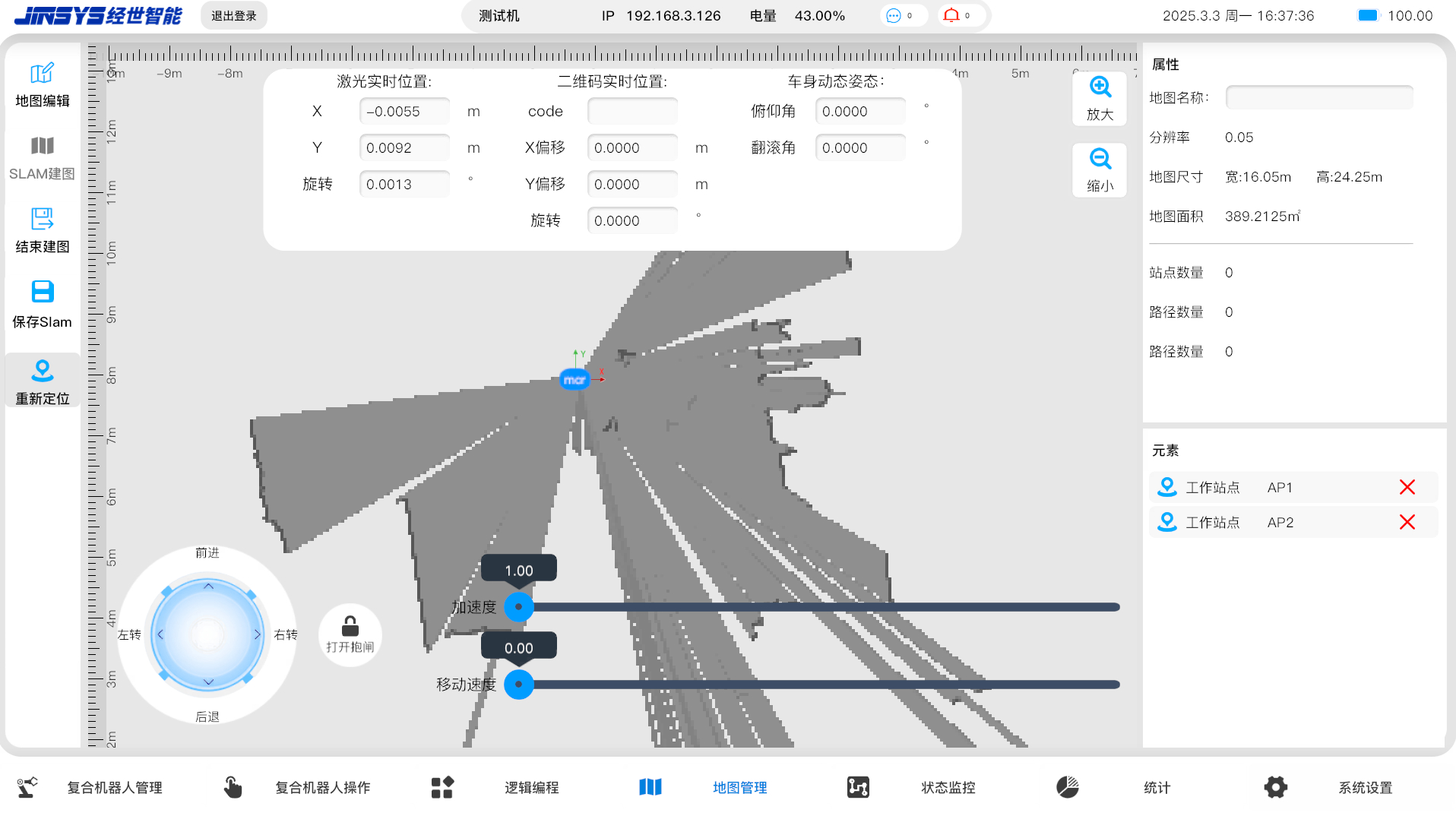
- SLAM mapping
- Finish mapping
- Save SLAM map
- Relocalize
- Edit map
Laser localization
- X: −0.0055 m
- Y: 0.0092 m
- Rotation: 0.0013°
- QR-code offsets: X 0 / Y 0 / rotation 0
Map properties
- Resolution: 0.05 m
- Dimensions: 16.05 m × 24.25 m
- Area: 389.2125 m²
- Stations: 0
- Paths: 0
Robot controls
- Forward / reverse
- Turn left / right
- Release brake
- Acceleration: 1.00
- Speed: 0
- Workstations AP1 / AP2
View original interface
- Map creation:Drive the robot using a keyboard or tablet touchscreen to build a 2D SLAM map. View incoming 2D point-cloud data in real time as the map is created.
- Map editing:Stitch point-cloud maps, erase regions, correct and re-edit maps, share maps, and mark zones.
- Map validation:Validate maps manually or automatically before sending them. Maps that fail validation cannot be sent.